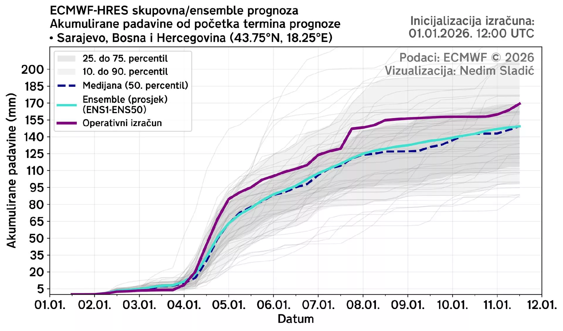
(Patria) - Meteorologist Nedim Sladić has prepared a forecast for the upcoming weekend and the beginning of the work week, announcing a change in weather that brings precipitation.
On Saturday, 01/03/2026, in most of the country, it will be mostly cloudy with precipitation, while in central Bosnia, it will be mostly partly clear and mostly dry. In the morning, the precipitation zone will move from the northwest towards the eastern Bosnian regions, where it will weaken by midday. It will mostly snow, initially sleet due to higher air temperatures. Due to the mixing of air masses with different properties and the presence of moisture in the lower layers of the atmosphere, temporarily heavier precipitation is forecast in northern Bosnia.
In Herzegovina, there will be occasional light rain throughout most of the day. Precipitation will intensify during the late evening hours and into the night towards Sunday, as it is influenced by a cyclonic field in the Adriatic, gradually spreading from the south towards central Bosnia, with conditions for thunderstorms along with rain and heavier showers. Wind after the passage of the frontal disturbance will be moderately to moderately strong from the northwest for a short time, then mostly light to moderate.
North of Sarajevo, the wind will maintain a colder component, while the south and southwest wind will be mostly south of the capital. In the evening, the southerly wind is strengthening in Herzegovina. Morning air temperature from -1 to 3 in northern and northwestern Bosnia, from 3 to 7 in central and southeastern Bosnia, and from 7 to 12 in Herzegovina, with daytime temperatures from 1 to 7, and from 7 to 12 °C in Herzegovina.
In Sarajevo, there will be intervals of partial clearing for most of the day. In the morning, due to more clouds, there may be occasional light drizzle. In the late evening hours, rain is expected, spreading from the direction of Herzegovina. Morning air temperature around 4, and daytime around 7 °C.
On Sunday, 01/04/2026, it will be mostly cloudy with heavier precipitation throughout the country. In the lower areas of northwestern and northern Bosnia, it will snow, while in the areas south of Zenica, it will initially rain, which will gradually turn into sleet and heavy wet snow by the morning. Due to the clash of different air masses over our areas, heavier precipitation is forecast for most of the day, with the formation of a snow cover. There will also be snow in the higher areas of northern and northwestern Herzegovina, while in southern Herzegovina, there will be rain and showers with thunderstorms.
In most of Bosnia, we expect a snow cover to form between 10 and 30 cm, locally up to 40 cm in the lowlands, and over half a meter in the mountains. Heavy and persistent precipitation in Herzegovina and southeastern Bosnia in the afternoon and evening can cause flash floods and urban flooding due to the large amount of precipitation in a short period, as well as landslides.
The wind south of Sarajevo will be mostly moderate to strong, with storm-force gusts in the mountains, from the south and southwest, and in northern Bosnia, from the north and northeast. Morning air temperature from 0 to 2 in northern and northwestern Bosnia, from 3 to 7 in central and southeastern Bosnia, and in Herzegovina from 7 to 14. Daytime air temperature in Bosnia will be from -4 to 0, in northern Herzegovina the temperature will drop with the afternoon, and will mostly range from -1 to 7, and in southern Herzegovina from 7 to 14 °C. In the evening, air temperatures will be single-digit everywhere.
In Sarajevo, it will be mostly cloudy with precipitation. Initially with rain, which will quickly turn into wet and dense snow in the morning, forming a snow cover. The morning will be the warmest part of the day, with a forecast air temperature around 6, and daytime around -1 °C.
On Monday, 01/05/2025, it will continue to be mostly cloudy with precipitation, but slightly less intense than on Sunday. It will mostly snow, and rain in southern Herzegovina. Due to the influx of warmer air from the south at higher altitudes, weak wind circulation at ground level, and the persistence of cold at ground level, snow will gradually turn into freezing (icy) rain in central and eastern Bosnia in most of the country.
As warmer air penetrates into the higher layers of the atmosphere, snow will gradually turn into rain in the higher mountains with the melting of the existing snow cover, which could worsen the existing hydrological situation. Snow is most likely throughout the day for the Bosanska Krajina region. Wind will be light to moderate from the southeast, and in northern Bosnia from the north and northeast. Morning air temperature from -4 to 1, from 2 to 10 in the south, and daytime from -3 to 0 °C in areas north of Zenica. From 2 to 7 south of Zenica, and from 7 to 11 °C in the south.
In Sarajevo, it will be mostly cloudy with snow, which will initially turn into freezing/icy rain with rising temperatures in the upper atmosphere, and then into rain as it penetrates the ground layer. Morning air temperature around -1, and daytime around 4 °C.
On Tuesday, 01/06/2026, the influence of cyclonic circulation approaching our areas will continue, bringing a new wave of precipitation. Precipitation will be mostly at the border of freezing rain and snow in Bosnia, and rain in Herzegovina, occasionally heavier, which can again cause flash floods. Air temperatures will be mostly from -5 to 2 in Bosnia, and from 1 in the north to 9 °C in the south of Herzegovina.
In Sarajevo, it will be mostly cloudy. There will be freezing rain, which will temporarily turn into snow again. The air temperature will be around 0 °C for most of the day.
Komentari (0)
Prijavite se za komentiranje
PrijavaJos nema komentara. Budite prvi!
Minuta
Sve →Iz drugih kategorija

High Representative Not Elected: Germans, French and British Sabotaged Americans, New Attempt at End of June

ČOVIĆ WITHOUT MERCY: How Those Who Brought Ademović to Office Created a Political Hell for Him



Sunny Saturday, quite warm


Tragedy in Albanian resort: Two minors drown