Prepared by: Nedim Sladić, amateur meteorologist
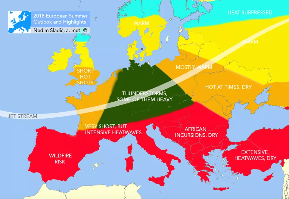
Analyzing long-term forecast models ECMWF (ECMWF-Meteo France), UK Met Office, IRI, JAMSTEC, Beijing Climate Center (BCC) and JMA, the conclusion of each output is an above-average hot summer over our area, with the average monthly temperature positively and significantly deviating for the June-July-August season. In a general context, the probability of the average monthly temperature deviation for the mentioned season from the long-term averages, the older one from 1961-1990 is very high, and moderate (around 55-60%) for the newer period 1981-2010.
Certainly, we expect heatwaves this summer as well, but they should be milder compared to last summer when temperatures often reached 43-44°C in the shade. However, there will certainly be no shortage of extremes this summer, as extreme weather conditions are becoming part of our daily lives and we need to get used to them. The largest temperature deviation is expected in July when the probability of North African heatwaves is highest, and they will also occur in August, primarily in the first half of the month.
When such warm air masses affect our area, temperatures are expected to be above or significantly above average, depending on the concentration of heat arriving in our area via the southwestern high-altitude current. However, this does not mean that it will be very hot throughout all three months. There will be occasional and short periods of about 2 to 4 days when temperatures will be temporarily at or slightly below the long-term average, but not enough to mitigate the pronounced positive temperature anomaly.
The model signal regarding precipitation is mixed, as precipitation is a more complex concept to determine its anomaly, but overall, with the further strengthening of the Azores High and the expansion of its ridge eastward, precipitation in Southern Europe will be less present and widespread than it was throughout most of May and the first part of June, which, thanks to the strong anticyclone over Northern Europe, caused the so-called "north-south split". Therefore, the summer will be drier than average, and it will be even drier in the second half of the summer (from mid-July to September) when longer periods of drier weather are also expected.
The summer should generally be more anticyclonic (stable) than cyclonic (unstable), and deep cyclones are not expected, while occasional shallow or, more likely, high-altitude cyclones are more probable, but their duration will be short. Precipitation will be exclusively in the form of showers, as is typical for the warmer part of the year.
CAUSES OF WEATHER INSTABILITY IN MAY
Although in the past twenty days in Bosnia and Herzegovina, and generally in neighboring countries, we can often read content related to thunderstorms, this is not an unusual situation for this time of year, as the primary precipitation maximum in Bosnia and Herzegovina is reached in May and the first half of June, caused by increased cyclonic activity over our area and the Mediterranean, and the second in October. This time, the reason for the instability is the so-called "North-South split". The "North-South split" is a term often used by meteorologists when a strong anticyclone prevails over Scandinavia and a large part of the UK, causing stable weather conditions, while Southern Europe is simultaneously under frequent incursions of moist and unstable air that penetrate the Mediterranean from across the Atlantic. The jet stream during May had a so-called "split", with a lot of energy separating into two branches, one directed north and the other towards Southern Europe.
With a very warm and, looking at this year in general, above-average warm Mediterranean, as rarely recorded in the past, as well as with above-average air temperatures that have existed since the beginning of April over most of Europe, there is a lot of evaporation and moisture in the upper layers, as well as potential energy that can very easily cause potent (strong) local thunderstorms, whose cloud development is vertical and the cloud type is often cumulonimbus (Cb), which can reach several kilometers in height, and which we witnessed on May 28 when 57 liters of rain fell on Sarajevo in a short period, which is slightly more than half of the average May rainfall. Also, the reason for intense rainfall is strong convection, which causes increased rainfall intensity (convective precipitation).
However, what is unusual is that there has been no significant cyclonic activity over Bosnia and Herzegovina for the entire month of May that would cause unstable weather conditions for a longer period, so precipitation manifests only in the form of rain showers, even despite the fact that we are in a field of medium uniform or slightly elevated atmospheric pressure (1015 hPa). The situation will not change, meaning the period of unstable weather with local showers and thunderstorms in the afternoon will continue.
There will be a hint of stabilization, as the long-lasting anticyclone over Northern Europe should gradually and finally weaken towards mid-June, which would give way to cyclonic activities, change the entire course of the jet stream to a purely straight zonal direction, and the Azores anticyclone would strengthen from Western Europe, calming the restless Mediterranean with higher atmospheric pressure. We could expect such a trend to occur over the Balkans only at the end of June. But generally speaking, June, despite the higher amount of precipitation, will be a quite humid and warm month with a significant positive temperature anomaly.
Another summer for which I can openly say will be enough to globally receive a climatological rating of "very hot" or even the usual for past summers - "extremely hot".
Komentari (0)
Prijavite se za komentiranje
PrijavaJos nema komentara. Budite prvi!
Minuta
Sve →Iz drugih kategorija

High Representative Not Elected: Germans, French and British Sabotaged Americans, New Attempt at End of June

ČOVIĆ WITHOUT MERCY: How Those Who Brought Ademović to Office Created a Political Hell for Him



Sunny Saturday, quite warm


Tragedy in Albanian resort: Two minors drown