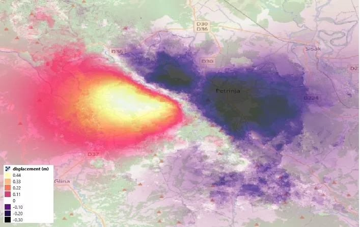
(Patria) - Satellite images with accompanying analysis have been released, revealing that the ground in Petrinja subsided by more than 10 centimeters due to the devastating earthquake. The images were published on Facebook by Alen Berta, a forestry engineer and consultant at the international company CGI responsible for planetary observation.
"The satellites show the full extent of the disaster. Comparing Sentinel 1 radar satellite images from December 18 and December 30, we can see that the ground west of Petrinja moved closer to the satellite by 44 cm in the most pronounced area, while the ground in Petrinja itself subsided (moved away from the satellite) by 10 to 30 cm. These areas have a radius of 10 km each. However, in the belt marked by the line Popovača, Sunja, Kostajnica, Dvor, we also observe a shift of a few centimeters, which was still devastating for many houses damaged by war and weather," Berta wrote.
In the Zagreb earthquake, the ground shifted only a few centimeters at the epicenter."
"Such ground displacement is on a larger scale than during the devastating earthquakes that occurred in Italy 3-4 years ago. Just to remind you, in the Zagreb earthquake, the ground shifted only a few centimeters at the epicenter itself, while in the city itself it was a few millimeters," the post states.
Komentari (0)
Prijavite se za komentiranje
PrijavaJos nema komentara. Budite prvi!
Minuta
Sve →Iz drugih kategorija

High Representative Not Elected: Germans, French and British Sabotaged Americans, New Attempt at End of June

ČOVIĆ WITHOUT MERCY: How Those Who Brought Ademović to Office Created a Political Hell for Him


Sunny Saturday, quite warm


Tragedy in Albanian resort: Two minors drown